GIS在县区级智慧环保平台应用
技术参照实现:
java实现克里金插值导出geojson矢量数据(kriging)_克里金插值法 java实现-CSDN博客
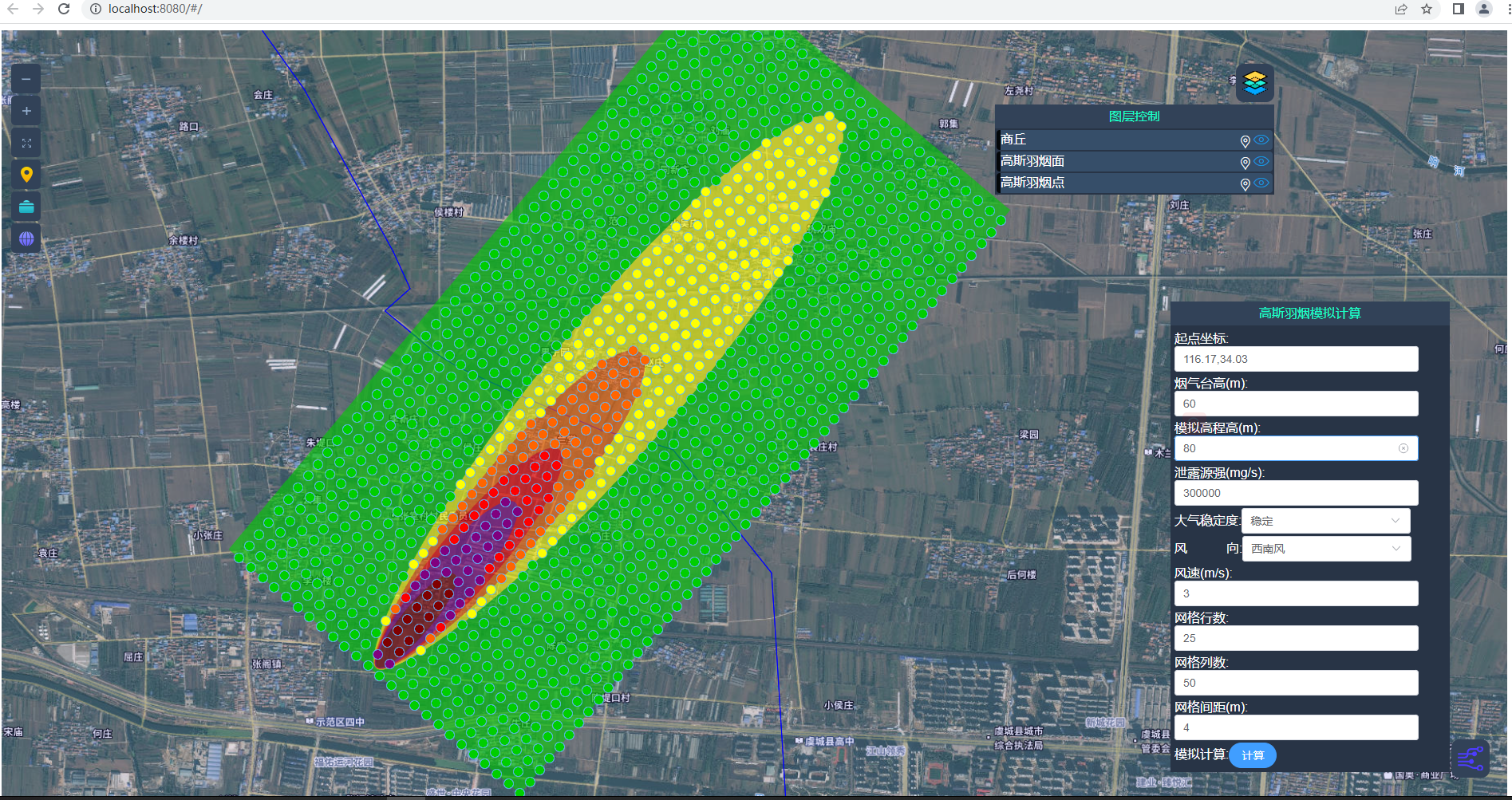
高斯羽烟gis应用java实现模型计算_java生成高斯羽烟等值面格网点-CSDN博客
java实现大气质量插值图及六项污染物插值图图片导出_java 根据数据生成插值图-CSDN博客
iClientOL实现前端gis开发架构_前端iclientol-CSDN博客
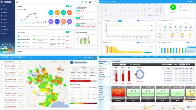
运用大数据、AI技术构建县区生态环境智慧监管平台,实现监测、预警、预防、处置全过程闭环管理。聚焦水、气、固废问题深度分析决策,为基层环保人员提供可靠依据,切实解决问题,推动监管精细化、决策可视化。
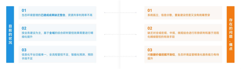
业务痛点
方案概述
运用大数据、人工智能等技术,结合县区生态环境管理业务的具体需求,构建县区生态环境智慧监管平台,实现对环境监测、分析预警、风险预防、任务处理的全过程监管,实现生态环境问题从自动监测识别到问题解决的闭环式管理;平台围绕突出的水环境、气环境、固体废物等问题进行深度的形势和决策分析,利用科学的技术方法向县区基层环保人员提供可靠的数据依据,切实解决县区生态环境问题。

方案组成
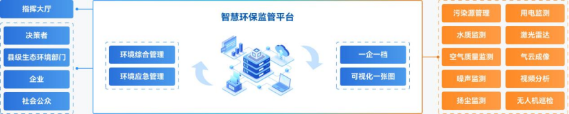
业务场景
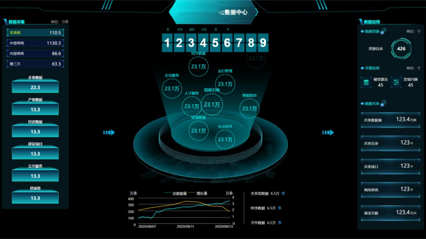
环境数据中心
环保大数据中心含数据基础、应用支撑平台。数据基础平台汇数据、维数据库、提服务,支持更新、报表导出。应用支撑平台供用户管理、权限、API等功能及统一用户管理、消息、日志等应用管理。
数据服务
数据集成
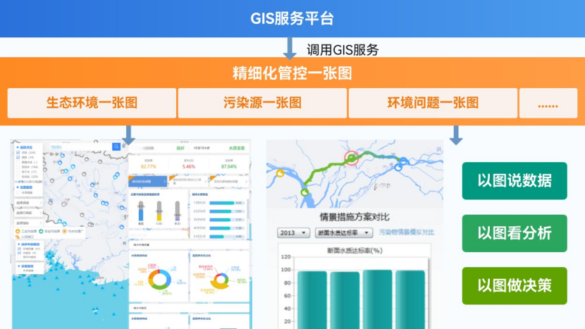
智慧环保一张图
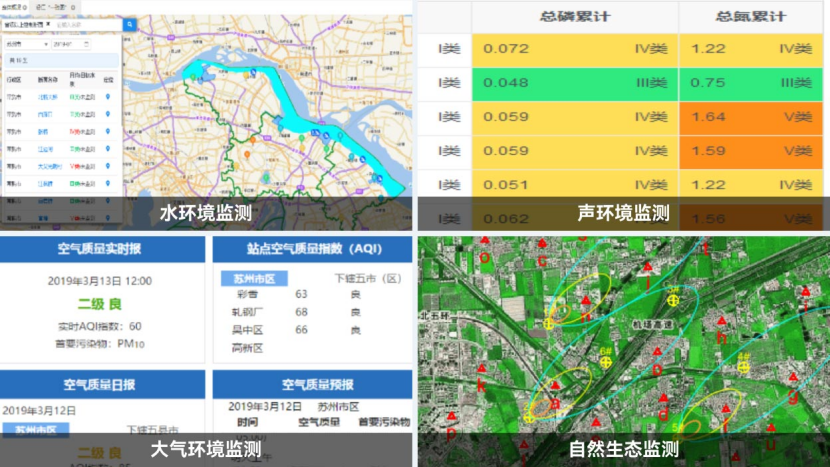
将分散的空气质量、水质、污染源、生态资源等各类环境信息,整合汇聚在一张电子地图上,实现环境状况“一图感知”、问题“一图定位”、风险“一图预警”、治理“一图调度”。做到以图说数据、以图看分析、以图做决策。
可视化分析
智能决策
环境综合监管
平台对水、气、土、声、废、渣等前端物联网数据进行汇聚和整合,实现实时监测、智能查询、实时报警、智能分析等,平台全面展示区域环境质量状况、污染源排污情况,为环境监督管理和治理规划提供基础数据和决策支持。
智能分析
全景展示
智慧监督管理
通过智能环境综合监测监控平台实时报警信息触发巡查任务,提供移动端监管手段,为领导、环境管理人员及一线工作人员提供移动办公功能。实现智能环境监控、智能预警、任务处置全流程管理。
移动监管联动
智能预警
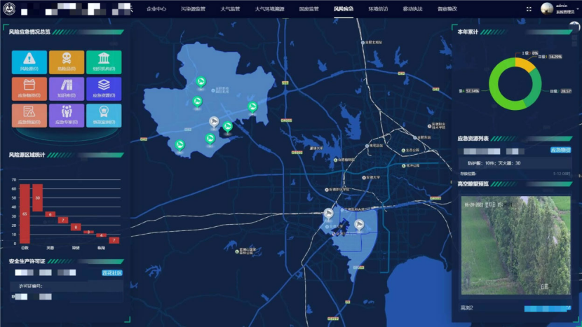
环境应急管理
建立智慧环境应急管理系统,提升生态环境系统的环境应急处置能力, 为环保行政主管部门提供应对突发环境事件的综合管理平台,平台实现对环境突发事件接报、处置、指挥、调度、评估的全过程闭环管理。
应急处置
综合指挥
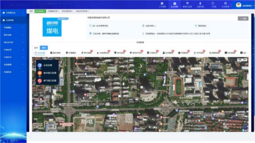
一企一档
污染源企业建立信息管理系统,便于监管部门的监督管理,企业档案信息包括企业基本信息、产品信息、产废信息、排污许可证信息、企业披露信息、污染源在线监测信息等,为环保部门执法和日常管理提供支持。
企业监督管理
典型案例
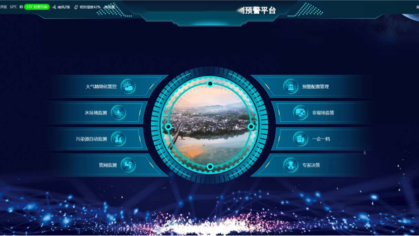
经济开发区环境监测预警平台
经济开发区环境监测预警平台,多维度环境监管智能化管理系统。涵盖大气监测、水环境监测、污染源监测、雨污管网监测、非现场监管、“一企一档” 、及专家决策系统等核心功能。通过 GIS一张图技术,将园区企业、监测点位可视化呈现于电子地图,通过多层穿透查询,实现空间分布直观管理。通过大数据算法及模型实现数据治理,系统依据使用者角色(如监管人员、企业管理者等)自动生成定制化报表。通过数据汇总、趋势分析与模型推演,预判环境发展方向,针对现有环境问题提供科学处置方案,为园区环境监管构建 “监测-预警-分析-决策” 全流程智能化管理体系。
关键技术代码实现:
import { Layersymbols } from '../SymbolsInfo/mapSymbols'
import GeoJSON from 'ol/format/GeoJSON'
import { getLyaerRenderSymbol } from '../MapCommon'
import { LayersRenderSet } from '../RendersInfo/LayersRenderSet'
import { formatDate } from "../gisUtils/DateUtil"
//JIEXIUTASK  t1chP@ssw0rd

export let layersInfo = {
  wyl: {
    layerCode: 'wyl',
    sourceType: 'ArcgisTile',
    title: '午夜蓝',
    url: 'https://map.geoq.cn/ArcGIS/rest/services/ChinaOnlineStreetPurplishBlue/MapServer',
    visible: false
  },
  // interpolationPic1: {
  //   layerCode:'interpolationPic1',
  //   isRLayerPanel: false,
  //   sourceType:'StaticImage',
  //   title:'底图',
  //   url: '/static/gisImage/11.png',
  //   extent: [-180,-90, 180,90],
  //   opacity: 1,
  //   location: {longitude: 119.10173927505058, latitude: 36.719213753859094, level: 4.721381872337247},
  //   visible: true
  // },
  // interpolationPic10: {
  //   layerCode:'interpolationPic10',
  //   isRLayerPanel: false,
  //   sourceType:'StaticImage',
  //   title:'底图',
  //   url: '/static/gisImage/ditu1.png',
  //   extent: [110.728963,36.338513, 113.166526,37.580859],
  //   opacity: 1,
  //   location: {longitude: 119.10173927505058, latitude: 38.719213753859094, level: 4.721381872337247},
  //   visible: true
  // },
  // XZQHRegion: {
  //   layerCode:'XZQHRegion',
  //   isRLayerPanel: true,
  //   sourceType: 'Vector',
  //   title: '行政区划',
  //   url: '/static/geojson/XZQH.json',
  //   dataPath:'',
  //   geoType: 'geojson',
  //   wrapX: false,
  //   opacity: 1,
  //   location: {longitude: 116.11704458402367, latitude: 34.25804927841997, level: 9.808516864898834},
  //   visible: true
  // },
  XZQHRegion: {
    layerCode:'XZQHRegion',
    isRLayerPanel: true,
    sourceType:'GeoVector',
    url:'/static/geojson/XZQH.json',
    title:'行政区划',
    style:Layersymbols.areaRegionSymbol,
    format: new GeoJSON(),
    wrapX: false,
    opacity: 1,
    location: {longitude: 118.52146158984375, latitude: 39.36146339453125, level: 9},
    visible:true
  },
  // interpolationPic2: {
  //   layerCode: 'interpolationPic2',
  //   isRLayerPanel: false,
  //   sourceType: 'StaticImage',
  //   title: '介休',
  //   url: '/static/gisImage/jiexiu.png',
  //   extent: [111.728963, 36.838513, 112.166526, 37.180859],
  //   opacity: 1,
  //   location: { longitude: 119.10173927505058, latitude: 36.719213753859094, level: 4.721381872337247 },
  //   visible: true
  // },
  FixedSource: {
    layerCode: 'FixedSource',
    isRLayerPanel: true,
    sourceType: 'Vector',
    title: '图标点',
    url: 'fixedSource/app/signature/search',
    rm: 'body',
    dataPath: 'data/records',
    params: { "labelMap": {}, "pageNum": 1, "pageSize": 2000, "wipollunit": "0,1" },
    dataLongitudeField: 'productionLon',
    dataLatitudeField: 'productionLat',
    dataIdField: 'id',
    geoType: 'point',
    isInit: true,
    floatLabelInfo: { floatLabelField: 'factoryName', offsetX: 10, offsetY: -40 },
    // maxZoom: 6,
    // minZoom: 4,
    wrapX: false,
    opacity: 1,
    location: { longitude: 116.11704458402367, latitude: 34.25804927841997, level: 9.808516864898834 },
    visible: false
  },
  FixedSource1: {
    layerCode: 'FixedSource1',
    isRLayerPanel: true,
    sourceType: 'Vector',
    title: '图标点',
    url: 'fixedSource/app/signature/search',
    rm: 'body',
    dataPath: 'data/records',
    params: { "labelMap": {}, "pageNum": 2, "pageSize": 5000, "wipollunit":"0,1" },
    dataLongitudeField: 'productionLon',
    dataLatitudeField: 'productionLat',
    dataIdField: 'id',
    geoType: 'point',
    isInit: true,
    floatLabelInfo: { floatLabelField: 'factoryName', offsetX: 10, offsetY: -40},
    // maxZoom: 6,
    // minZoom: 4,
    wrapX: false,
    opacity: 1,
    location: { longitude: 116.11704458402367, latitude: 34.25804927841997, level: 9.808516864898834 },
    visible: false
  },
  FixedSource2: {
    layerCode: 'FixedSource2',
    isRLayerPanel: true,
    sourceType: 'Vector',
    title: '图标点',
    url: 'fixedSource/app/signature/search',
    rm: 'body',
    dataPath: 'data/records',
    params: { "labelMap": {}, "pageNum": 3, "pageSize": 100000, "wipollunit":"0,1" },
    dataLongitudeField: 'productionLon',
    dataLatitudeField: 'productionLat',
    dataIdField: 'id',
    geoType: 'point',
    isInit: true,
    floatLabelInfo: { floatLabelField: 'factoryName', offsetX: 10, offsetY: -40 },
    // maxZoom: 6,
    // minZoom: 4,
    wrapX: false,
    opacity: 1,
    location: { longitude: 116.11704458402367, latitude: 34.25804927841997, level: 9.808516864898834 },
    visible: false
  },

  // RoadDust
  GT: {
    layerCode: 'GT',
    isRLayerPanel: true,
    isInit: true,
    sourceType: 'Vector',
    title: '钢铁',
    url: '/fixedSource/map/pollutantSources',
    dataPath: 'data',
    params: {
      type: 'GT'
    },
    dataLongitudeField: 'longitude',
    dataLatitudeField: 'latitude',
    dataIdField: 'longitude',
    geoType: 'point',
    labelField: 'tname',
    tname: '钢',
    maxZoom: Infinity,
    minZoom: -Infinity,
    wrapX: false,
    opacity: 1,
    location: { longitude: 116.11704458402367, latitude: 34.25804927841997, level: 9.808516864898834 },
    visible: false
  },
  // WorkerDust
  JH: {
    layerCode: 'JH',
    isRLayerPanel: true,
    isInit: true,
    sourceType: 'Vector',
    title: '焦化',
    url: '/fixedSource/map/pollutantSources',
    dataPath: 'data',
    params: {
      type: 'JH'
    },
    dataLongitudeField: 'longitude',
    dataLatitudeField: 'latitude',
    dataIdField: 'longitude',
    geoType: 'point',
    labelField: 'tname',
    tname: '焦',
    maxZoom: Infinity,
    minZoom: -Infinity,
    wrapX: false,
    opacity: 1,
    location: { longitude: 116.11704458402367, latitude: 34.25804927841997, level: 9.808516864898834 },
    visible: false
  },
  // Drink
  SN: {
    layerCode: 'SN',
    isRLayerPanel: true,
    isInit: true,
    sourceType: 'Vector',
    title: '水泥',
    url: '/fixedSource/map/pollutantSources',
    dataPath: 'data',
    params: {
      type: 'SN'
    },
    dataLongitudeField: 'longitude',
    dataLatitudeField: 'latitude',
    dataIdField: 'longitude',
    geoType: 'point',
    labelField: 'tname',
    tname: '水',
    maxZoom: Infinity,
    minZoom: -Infinity,
    wrapX: false,
    opacity: 1,
    location: { longitude: 116.11704458402367, latitude: 34.25804927841997, level: 9.808516864898834 },
    visible: false
  },
  // Industry
  DL: {
    layerCode: 'DL',
    isRLayerPanel: true,
    isInit: true,
    sourceType: 'Vector',
    title: '电力',
    url: '/fixedSource/map/pollutantSources',
    dataPath: 'data',
    params: {
      type: 'DL'
    },
    dataLongitudeField: 'longitude',
    dataLatitudeField: 'latitude',
    dataIdField: 'longitude',
    geoType: 'point',
    labelField: 'tname',
    tname: '电',
    maxZoom: Infinity,
    minZoom: -Infinity,
    wrapX: false,
    opacity: 1,
    location: { longitude: 116.11704458402367, latitude: 34.25804927841997, level: 9.808516864898834 },
    visible: false
  },
  TS: {
    layerCode: 'TS',
    isRLayerPanel: true,
    isInit: true,
    sourceType: 'Vector',
    title: '碳素',
    url: '/fixedSource/map/pollutantSources',
    dataPath: 'data',
    params: {
      type: 'TS'
    },
    dataLongitudeField: 'longitude',
    dataLatitudeField: 'latitude',
    dataIdField: 'longitude',
    geoType: 'point',
    labelField: 'tname',
    tname: '碳',
    maxZoom: Infinity,
    minZoom: -Infinity,
    wrapX: false,
    opacity: 1,
    location: { longitude: 116.11704458402367, latitude: 34.25804927841997, level: 9.808516864898834 },
    visible: false
  },
  BH: {
    layerCode: 'BH',
    isRLayerPanel: true,
    isInit: true,
    sourceType: 'Vector',
    title: '白灰',
    url: '/fixedSource/map/pollutantSources',
    dataPath: 'data',
    params: {
      type: 'BH'
    },
    dataLongitudeField: 'longitude',
    dataLatitudeField: 'latitude',
    dataIdField: 'longitude',
    geoType: 'point',
    labelField: 'tname',
    tname: '白',
    maxZoom: Infinity,
    minZoom: -Infinity,
    wrapX: false,
    opacity: 1,
    location: { longitude: 116.11704458402367, latitude: 34.25804927841997, level: 9.808516864898834 },
    visible: false
  },
  GR: {
    layerCode: 'GR',
    isRLayerPanel: true,
    isInit: true,
    sourceType: 'Vector',
    title: '供热',
    url: '/fixedSource/map/pollutantSources',
    dataPath: 'data',
    params: {
      type: 'GR'
    },
    dataLongitudeField: 'longitude',
    dataLatitudeField: 'latitude',
    dataIdField: 'longitude',
    geoType: 'point',
    labelField: 'tname',
    tname: '热',
    maxZoom: Infinity,
    minZoom: -Infinity,
    wrapX: false,
    opacity: 1,
    location: { longitude: 116.11704458402367, latitude: 34.25804927841997, level: 9.808516864898834 },
    visible: false
  },
  HG: {
    layerCode: 'HG',
    isRLayerPanel: true,
    isInit: true,
    sourceType: 'Vector',
    title: '化工',
    url: '/fixedSource/map/pollutantSources',
    dataPath: 'data',
    params: {
      type: 'HG'
    },
    dataLongitudeField: 'longitude',
    dataLatitudeField: 'latitude',
    dataIdField: 'longitude',
    geoType: 'point',
    labelField: 'tname',
    tname: '化',
    maxZoom: Infinity,
    minZoom: -Infinity,
    wrapX: false,
    opacity: 1,
    location: { longitude: 116.11704458402367, latitude: 34.25804927841997, level: 9.808516864898834 },
    visible: false
  },
  LFT: {
    layerCode: 'LFT',
    isRLayerPanel: true,
    isInit: true,
    sourceType: 'Vector',
    title: '铝矾土',
    url: '/fixedSource/map/pollutantSources',
    dataPath: 'data',
    params: {
      type: 'LFT'
    },
    dataLongitudeField: 'longitude',
    dataLatitudeField: 'latitude',
    dataIdField: 'longitude',
    geoType: 'point',
    labelField: 'tname',
    tname: '铝',
    maxZoom: Infinity,
    minZoom: -Infinity,
    wrapX: false,
    opacity: 1,
    location: { longitude: 116.11704458402367, latitude: 34.25804927841997, level: 9.808516864898834 },
    visible: false
  },
  TC: {
    layerCode: 'TC',
    isRLayerPanel: true,
    isInit: true,
    sourceType: 'Vector',
    title: '陶瓷',
    url: '/fixedSource/map/pollutantSources',
    dataPath: 'data',
    params: {
      type: 'TC'
    },
    dataLongitudeField: 'longitude',
    dataLatitudeField: 'latitude',
    dataIdField: 'longitude',
    geoType: 'point',
    labelField: 'tname',
    tname: '陶',
    maxZoom: Infinity,
    minZoom: -Infinity,
    wrapX: false,
    opacity: 1,
    location: { longitude: 116.11704458402367, latitude: 34.25804927841997, level: 9.808516864898834 },
    visible: false
  },
  ZC: {
    layerCode: 'ZC',
    isRLayerPanel: true,
    isInit: true,
    sourceType: 'Vector',
    title: '砖厂',
    url: '/fixedSource/map/pollutantSources',
    dataPath: 'data',
    params: {
      type: 'ZC'
    },
    dataLongitudeField: 'longitude',
    dataLatitudeField: 'latitude',
    dataIdField: 'longitude',
    geoType: 'point',
    labelField: 'tname',
    tname: '砖',
    maxZoom: Infinity,
    minZoom: -Infinity,
    wrapX: false,
    opacity: 1,
    location: { longitude: 116.11704458402367, latitude: 34.25804927841997, level: 9.808516864898834 },
    visible: false
  },
  SWZ: {
    layerCode: 'SWZ',
    isRLayerPanel: true,
    isInit: true,
    sourceType: 'Vector',
    title: '生物质发电',
    url: '/fixedSource/map/pollutantSources',
    dataPath: 'data',
    params: {
      type: 'SWZ'
    },
    dataLongitudeField: 'longitude',
    dataLatitudeField: 'latitude',
    dataIdField: 'longitude',
    geoType: 'point',
    labelField: 'tname',
    tname: '生',
    maxZoom: Infinity,
    minZoom: -Infinity,
    wrapX: false,
    opacity: 1,
    location: { longitude: 116.11704458402367, latitude: 34.25804927841997, level: 9.808516864898834 },
    visible: false
  },
  MK: {
    layerCode: 'MK',
    isRLayerPanel: true,
    isInit: true,
    sourceType: 'Vector',
    title: '煤矿',
    url: '/fixedSource/map/pollutantSources',
    dataPath: 'data',
    params: {
      type: 'MK'
    },
    dataLongitudeField: 'longitude',
    dataLatitudeField: 'latitude',
    dataIdField: 'longitude',
    geoType: 'point',
    labelField: 'tname',
    tname: '煤',
    maxZoom: Infinity,
    minZoom: -Infinity,
    wrapX: false,
    opacity: 1,
    location: { longitude: 116.11704458402367, latitude: 34.25804927841997, level: 9.808516864898834 },
    visible: false
  },
  WS: {
    layerCode: 'WS',
    isRLayerPanel: true,
    isInit: true,
    sourceType: 'Vector',
    title: '污水处理',
    url: '/fixedSource/map/pollutantSources',
    dataPath: 'data',
    params: {
      type: 'WS'
    },
    dataLongitudeField: 'longitude',
    dataLatitudeField: 'latitude',
    dataIdField: 'longitude',
    geoType: 'point',
    labelField: 'tname',
    tname: '污',
    maxZoom: Infinity,
    minZoom: -Infinity,
    wrapX: false,
    opacity: 1,
    location: { longitude: 116.11704458402367, latitude: 34.25804927841997, level: 9.808516864898834 },
    visible: false
  },
  //新的高空瞭望
  HighMonitor: {
    layerCode: 'HighMonitor',
    isRLayerPanel: true,
    isInit:true,
    sourceType: 'Vector',
    title: '高空瞭望',
    url: '/talroad-multi-source-fusion/highVideo/dhvideos',
    dataPath: 'data',
    params: {},
    dataLongitudeField: 'longitude',
    dataLatitudeField: 'latitude',
    dataIdField: 'longitude',
    geoType: 'point',
    labelField: 'tname',
    tname: '',
    maxZoom: Infinity,
    minZoom: -Infinity,
    wrapX: false,
    opacity: 1,
    location: {longitude: 116.11704458402367, latitude: 34.25804927841997, level: 9.808516864898834},
    visible: false,
    floatLabelInfo: {floatLabelField: 'deviceName', offsetX: 10, offsetY: -40}
  },
  UAV1: {
    layerCode: 'UAV1',
    isRLayerPanel: true,
    // isStrong: true,
    isInit:true,
    sourceType: 'Vector',
    title: '绵山镇机库',
    url: '/talroad-multi-source-fusion/homePage/historyMapStationData',
    dataPath: 'data',
    params: {
      factorName: 'pm25', dateType: 1, monitorTime: formatDate(new Date(new Date().setHours(new Date().getHours() - 2)), 'yyyy-MM-dd hh:00:00'), stationLevel: 30, regionCode: 0
    },
    dataLongitudeField: 'longitude',
    dataLatitudeField: 'latitude',
    dataIdField: 'longitude',
    geoType: 'point',
    labelField: 'tname',
    tname: '',
    maxZoom: Infinity,
    minZoom: 9.01,
    // groupLayers:[],
    // outRes:[],
    // isGroupLayer: true,
    wrapX: false,
    opacity: 1,
    location: { longitude: 111.8916531, latitude: 37.001733, level: 9.808516864898834 },
    visible: false,
    floatLabelInfo: {floatLabelField: 'name', offsetX: 10, offsetY: -40}
  },
  // OilStation
  BL: {
    layerCode: 'BL',
    isRLayerPanel: true,
    isInit: true,
    sourceType: 'Vector',
    title: '玻璃',
    url: '/fixedSource/map/pollutantSources',
    dataPath: 'data',
    params: {
      type: 'BL'
    },
    dataLongitudeField: 'longitude',
    dataLatitudeField: 'latitude',
    dataIdField: 'longitude',
    geoType: 'point',
    labelField: 'tname',
    tname: '玻',
    maxZoom: Infinity,
    minZoom: -Infinity,
    wrapX: false,
    opacity: 1,
    location: { longitude: 116.11704458402367, latitude: 34.25804927841997, level: 9.808516864898834 },
    visible: false
  },
  // CarRepair
  FS: {
    layerCode: 'FS',
    isRLayerPanel: true,
    isInit: true,
    sourceType: 'Vector',
    title: '垃圾焚烧',
    url: '/fixedSource/map/pollutantSources',
    dataPath: 'data',
    params: {
      type: 'FS'
    },
    dataLongitudeField: 'longitude',
    dataLatitudeField: 'latitude',
    dataIdField: 'longitude',
    geoType: 'point',
    labelField: 'tname',
    tname: '垃',
    maxZoom: Infinity,
    minZoom: -Infinity,
    wrapX: false,
    opacity: 1,
    location: { longitude: 116.11704458402367, latitude: 34.25804927841997, level: 9.808516864898834 },
    visible: false
  },
  // Parking
  EL: {
    layerCode: 'EL',
    isRLayerPanel: true,
    isInit: true,
    sourceType: 'Vector',
    title: '分表计电',
    url: '/fixedSource/map/pollutantSources',
    dataPath: 'data',
    params: {
      type: 'EL'
    },
    dataLongitudeField: 'longitude',
    dataLatitudeField: 'latitude',
    dataIdField: 'longitude',
    geoType: 'point',
    labelField: 'tname',
    tname: '分',
    maxZoom: Infinity,
    minZoom: -Infinity,
    wrapX: false,
    opacity: 1,
    location: { longitude: 116.11704458402367, latitude: 34.25804927841997, level: 9.808516864898834 },
    visible: false
  },
  MoveSource: {
    layerCode: 'MoveSource',
    isRLayerPanel: true,
    isInit: true,
    sourceType: 'Vector',
    title: '移动源',
    url: '/talroad-multi-source-fusion/map/pollutantSources',
    dataPath: 'data',
    params: {
      type: 11
    },
    dataLongitudeField: 'longitude',
    dataLatitudeField: 'latitude',
    dataIdField: 'longitude',
    geoType: 'point',
    labelField: 'tname',
    tname: '移',
    maxZoom: Infinity,
    minZoom: -Infinity,
    wrapX: false,
    opacity: 1,
    location: { longitude: 116.11704458402367, latitude: 34.25804927841997, level: 9.808516864898834 },
    visible: false
  },
  Fossil: {
    layerCode: 'Fossil',
    isRLayerPanel: true,
    isInit: true,
    sourceType: 'Vector',
    title: '散煤及生物质燃烧',
    url: '/talroad-multi-source-fusion/map/pollutantSources',
    dataPath: 'data',
    params: {
      type: 12
    },
    dataLongitudeField: 'longitude',
    dataLatitudeField: 'latitude',
    dataIdField: 'longitude',
    geoType: 'point',
    labelField: 'tname',
    tname: '散',
    maxZoom: Infinity,
    minZoom: -Infinity,
    wrapX: false,
    opacity: 1,
    location: { longitude: 116.11704458402367, latitude: 34.25804927841997, level: 9.808516864898834 },
    visible: false
  },
  rsMonitor1: {
    layerCode: 'rsMonitor1',
    isRLayerPanel: true,
    isStrong: true,
    sourceType: 'Vector',
    title: '遥感',
    url: '/talroad-multi-source-fusion/homePage/historyMapStationData',
    dataPath: 'data',
    params: {
      factorName: 'pm25', dateType: 1, monitorTime: formatDate(new Date(new Date().setHours(new Date().getHours() - 2)), 'yyyy-MM-dd hh:00:00'), stationLevel: 29
    },
    dataLongitudeField: 'longitude',
    dataLatitudeField: 'latitude',
    dataIdField: 'longitude',
    geoType: 'point',
    labelField: 'value',
    maxZoom: Infinity,
    minZoom: 9.01,
    wrapX: false,
    opacity: 1,
    location: { longitude: 116.11704458402367, latitude: 34.25804927841997, level: 9.808516864898834 },
    visible: false
  },
  WeiMonitor1: {
    layerCode: 'WeiMonitor1',
    isRLayerPanel: true,
    isStrong: true,
    sourceType: 'Vector',
    title: '微站',
    url: '/talroad-multi-source-fusion/homePage/historyMapStationData',
    dataPath: 'data',
    params: {
      factorName: 'pm25', dateType: 1, monitorTime: formatDate(new Date(new Date().setHours(new Date().getHours() - 2)), 'yyyy-MM-dd hh:00:00'), stationLevel: 10, regionCode: 0
    },
    dataLongitudeField: 'longitude',
    dataLatitudeField: 'latitude',
    floatLabelInfo: { floatLabelField: 'name', offsetX: 10, offsetY: -40},
    dataIdField: 'longitude',
    geoType: 'point',
    labelField: 'value',
    // maxZoom: Infinity,
    // minZoom: 9.01,
    wrapX: false,
    opacity: 1,
    location: { longitude: 116.11704458402367, latitude: 34.25804927841997, level: 9.808516864898834 },
    visible: false
  },
  ShiMonitor1: {
    layerCode: 'ShiMonitor1',
    isRLayerPanel: true,
    isStrong: true,
    sourceType: 'Vector',
    title: '市控',
    url: '/talroad-multi-source-fusion/homePage/historyMapStationData',
    dataPath: 'data',
    params: {
      factorName: 'pm25', dateType: 1, monitorTime: formatDate(new Date(new Date().setHours(new Date().getHours() - 2)), 'yyyy-MM-dd hh:00:00'), stationLevel: 3, regionCode: 0
    },
    dataLongitudeField: 'longitude',
    dataLatitudeField: 'latitude',
    dataIdField: 'longitude',
    geoType: 'point',
    labelField: 'value',
    floatLabelInfo: { floatLabelField: 'name', offsetX: 10, offsetY: -40},
    // maxZoom: Infinity,
    // minZoom: 9.01,
    wrapX: false,
    opacity: 1,
    location: { longitude: 116.11704458402367, latitude: 34.25804927841997, level: 9.808516864898834 },
    visible: false
  },
  ShengMonitor1: {
    layerCode: 'ShengMonitor1',
    isRLayerPanel: true,
    isStrong: true,
    isInit: true,
    sourceType: 'Vector',
    title: '省控',
    url: '/talroad-multi-source-fusion/homePage/historyMapStationData',
    dataPath: 'data',
    params: {
      factorName: 'pm25', dateType: 1, monitorTime: formatDate(new Date(new Date().setHours(new Date().getHours() - 2)), 'yyyy-MM-dd hh:00:00'), stationLevel: 2, regionCode: 0
    },
    dataLongitudeField: 'longitude',
    dataLatitudeField: 'latitude',
    dataIdField: 'longitude',
    geoType: 'point',
    labelField: 'value',
    floatLabelInfo: { floatLabelField: 'name', offsetX: 10, offsetY: -40},
    // maxZoom: Infinity,
    // minZoom: 9.01,
    wrapX: false,
    opacity: 1,
    location: { longitude: 116.11704458402367, latitude: 34.25804927841997, level: 9.808516864898834 },
    visible: false
  },
  GuoMonitor1: {
    layerCode: 'GuoMonitor1',
    isRLayerPanel: true,
    isStrong: true,
    sourceType: 'Vector',
    title: '国控',
    url: '/talroad-multi-source-fusion/homePage/historyMapStationData',
    dataPath: 'data',
    params: {
      factorName: 'pm25', dateType: 1, monitorTime: formatDate(new Date(new Date().setHours(new Date().getHours() - 2)), 'yyyy-MM-dd hh:00:00'), stationLevel: 1
    },
    dataLongitudeField: 'longitude',
    dataLatitudeField: 'latitude',
    dataIdField: 'longitude',
    geoType: 'point',
    labelField: 'value',
    floatLabelInfo: { floatLabelField: 'name', offsetX: 10, offsetY: -40},
    // maxZoom: Infinity,
    // minZoom: 9.01,
    wrapX: false,
    opacity: 1,
    location: { longitude: 116.11704458402367, latitude: 34.25804927841997, level: 9.808516864898834 },
    visible: false
  },
  rsMonitor1l: {
    layerCode: 'rsMonitor1l',
    isRLayerPanel: true,
    isStrong: true,
    sourceType: 'Vector',
    title: '遥感标注',
    url: '/talroad-multi-source-fusion/homePage/historyMapStationData',
    dataPath: 'data',
    params: {
      factorName: 'pm25', dateType: 1, monitorTime: formatDate(new Date(new Date().setHours(new Date().getHours() - 2)), 'yyyy-MM-dd hh:00:00'), stationLevel: 29
    },
    dataLongitudeField: 'longitude',
    dataLatitudeField: 'latitude',
    dataIdField: 'longitude',
    geoType: 'pointl',
    labelField: 'value',
    maxZoom: Infinity,
    minZoom: 16.01,
    // groupLayers:[],
    // outRes:[],
    isGroupLayer: false,
    wrapX: false,
    opacity: 1,
    location: { longitude: 116.11704458402367, latitude: 34.25804927841997, level: 9.808516864898834 },
    visible: false
  },
  // WeiMonitor1l: {
  //   layerCode: 'WeiMonitor1l',
  //   isRLayerPanel: true,
  //   isStrong: true,
  //   sourceType: 'Vector',
  //   title: '微站标注',
  //   url: '/talroad-multi-source-fusion/homePage/historyMapStationData',
  //   dataPath: 'data',
  //   params: {
  //     factorName: 'pm25', dateType: 1, monitorTime: formatDate(new Date(new Date().setHours(new Date().getHours() - 2)), 'yyyy-MM-dd hh:00:00'), stationLevel: 10, regionCode: 0
  //   },
  //   dataLongitudeField: 'longitude',
  //   dataLatitudeField: 'latitude',
  //   dataIdField: 'longitude',
  //   floatLabelInfo: { floatLabelField: 'name', offsetX: 10, offsetY: -16},
  //   geoType: 'pointl',
  //   labelField: 'value',
  //   maxZoom: Infinity,
  //   minZoom: 16.01,
  //   wrapX: false,
  //   opacity: 1,
  //   location: { longitude: 116.11704458402367, latitude: 34.25804927841997, level: 9.808516864898834 },
  //   visible: false
  // },
  // ShiMonitor1l: {
  //   layerCode: 'ShiMonitor1l',
  //   isRLayerPanel: true,
  //   isStrong: true,
  //   sourceType: 'Vector',
  //   title: '市控标注',
  //   url: '/talroad-multi-source-fusion/homePage/historyMapStationData',
  //   dataPath: 'data',
  //   params: {
  //     factorName: 'pm25', dateType: 1, monitorTime: formatDate(new Date(new Date().setHours(new Date().getHours() - 2)), 'yyyy-MM-dd hh:00:00'), stationLevel: 3, regionCode: 0
  //   },
  //   dataLongitudeField: 'longitude',
  //   dataLatitudeField: 'latitude',
  //   dataIdField: 'longitude',
  //   geoType: 'pointl',
  //   labelField: 'value',
  //   maxZoom: Infinity,
  //   minZoom: 9.01,
  //   floatLabelInfo: { floatLabelField: 'name', offsetX: 10, offsetY: -16},
  //   // groupLayers:[],
  //   // outRes:[],
  //   isGroupLayer: false,
  //   wrapX: false,
  //   opacity: 1,
  //   location: { longitude: 116.11704458402367, latitude: 34.25804927841997, level: 9.808516864898834 },
  //   visible: false
  // },
  // ShengMonitor1l: {
  //   layerCode: 'ShengMonitor1l',
  //   isRLayerPanel: true,
  //   isStrong: true,
  //   sourceType: 'Vector',
  //   title: '省控标注',
  //   url: '/talroad-multi-source-fusion/homePage/historyMapStationData',
  //   dataPath: 'data',
  //   params: {
  //     factorName: 'pm25', dateType: 1, monitorTime: formatDate(new Date(new Date().setHours(new Date().getHours() - 2)), 'yyyy-MM-dd hh:00:00'), stationLevel: 2, regionCode: 0
  //   },
  //   dataLongitudeField: 'longitude',
  //   dataLatitudeField: 'latitude',
  //   dataIdField: 'longitude',
  //   geoType: 'pointl',
  //   labelField: 'value',
  //   floatLabelInfo: { floatLabelField: 'name', offsetX: 10, offsetY: -16},
  //   maxZoom: Infinity,
  //   minZoom: 9.01,
  //   // groupLayers:[],
  //   // outRes:[],
  //   isGroupLayer: false,
  //   wrapX: false,
  //   opacity: 1,
  //   location: { longitude: 116.11704458402367, latitude: 34.25804927841997, level: 9.808516864898834 },
  //   visible: false
  // },
  // GuoMonitor1l: {
  //   layerCode: 'GuoMonitor1l',
  //   isRLayerPanel: true,
  //   isStrong: true,
  //   sourceType: 'Vector',
  //   title: '国控标注',
  //   url: '/talroad-multi-source-fusion/homePage/historyMapStationData',
  //   dataPath: 'data',
  //   params: {
  //     factorName: 'pm25', dateType: 1, monitorTime: formatDate(new Date(new Date().setHours(new Date().getHours() - 2)), 'yyyy-MM-dd hh:00:00'), stationLevel: 1, regionCode: 0
  //   },
  //   dataLongitudeField: 'longitude',
  //   dataLatitudeField: 'latitude',
  //   dataIdField: 'longitude',
  //   geoType: 'pointl',
  //   labelField: 'value',
  //   floatLabelInfo: { floatLabelField: 'name', offsetX: 10, offsetY: -16},
  //   maxZoom: Infinity,
  //   minZoom: 9.01,
  //   // groupLayers:[],
  //   // outRes:[],
  //   isGroupLayer: false,
  //   wrapX: false,
  //   opacity: 1,
  //   location: { longitude: 116.11704458402367, latitude: 34.25804927841997, level: 9.808516864898834 },
  //   visible: false
  // },
  CRegion: {
    layerCode: 'CRegion',
    sourceType: 'Vector',
    title: '绘制区域',
    wrapX: false,
    isModify: true,
    opacity: 1,
    visible: false
  },
  LS: {
    layerCode: 'LS',
    sourceType: 'Vector',
    title: '临时',
    wrapX: false,
    opacity: 1,
    visible: true
  }
}
export let layersInfoYunTu = {
  aqiyunTuLayers1: {
    layerCode: 'aqiyunTuLayers1',
    isRLayerPanel: true,
    sourceType: 'GeoVector',
    url: '/interpolation-api1/api/export/EDVRVec1?avgType=1&factor=aqi',
    title: '插值图',
    style: function (feature, resolution) {
      if (getLyaerRenderSymbol(LayersRenderSet, "aqiyunTuLayers1", feature.values_) != null) {
        feature.setStyle(getLyaerRenderSymbol(LayersRenderSet, "aqiyunTuLayers1", feature.values_))
      } else {
        feature.setStyle(Layersymbols.areaRegionSymbol)
      }
    },
    format: new GeoJSON(),
    wrapX: false,
    opacity: 1,
    location: { longitude: 118.07340729509488, latitude: 36.57598598661498, level: 9.7 },
    visible: false
  },
  aqiyunTuLayers2: {
    layerCode: 'aqiyunTuLayers2',
    isRLayerPanel: true,
    sourceType: 'GeoVector',
    url: '/interpolation-api1/api/export/EDVRVec1?avgType=2&factor=aqi',
    title: '插值图',
    style: function (feature, resolution) {
      if (getLyaerRenderSymbol(LayersRenderSet, "aqiyunTuLayers2", feature.values_) != null) {
        feature.setStyle(getLyaerRenderSymbol(LayersRenderSet, "aqiyunTuLayers2", feature.values_))
      } else {
        feature.setStyle(Layersymbols.areaRegionSymbol)
      }
    },
    format: new GeoJSON(),
    wrapX: false,
    opacity: 1,
    location: { longitude: 118.07340729509488, latitude: 36.57598598661498, level: 9.7 },
    visible: false
  },
  so2yunTuLayers1: {
    layerCode: 'so2yunTuLayers1',
    isRLayerPanel: true,
    sourceType: 'GeoVector',
    url: '/interpolation-api1/api/export/EDVRVec1?avgType=1&factor=so2',
    title: '插值图',
    style: function (feature, resolution) {
      if (getLyaerRenderSymbol(LayersRenderSet, "so2yunTuLayers1", feature.values_) != null) {
        feature.setStyle(getLyaerRenderSymbol(LayersRenderSet, "so2yunTuLayers1", feature.values_))
      } else {
        feature.setStyle(Layersymbols.areaRegionSymbol)
      }
    },
    format: new GeoJSON(),
    wrapX: false,
    opacity: 1,
    location: { longitude: 118.07340729509488, latitude: 36.57598598661498, level: 9.7 },
    visible: false
  },
  so2yunTuLayers2: {
    layerCode: 'so2yunTuLayers2',
    isRLayerPanel: true,
    sourceType: 'GeoVector',
    url: '/interpolation-api1/api/export/EDVRVec1?avgType=2&factor=aqi',
    title: '插值图',
    style: function (feature, resolution) {
      if (getLyaerRenderSymbol(LayersRenderSet, "so2yunTuLayers2", feature.values_) != null) {
        feature.setStyle(getLyaerRenderSymbol(LayersRenderSet, "so2yunTuLayers2", feature.values_))
      } else {
        feature.setStyle(Layersymbols.areaRegionSymbol)
      }
    },
    format: new GeoJSON(),
    wrapX: false,
    opacity: 1,
    location: { longitude: 118.07340729509488, latitude: 36.57598598661498, level: 9.7 },
    visible: false
  },
  no2yunTuLayers1: {
    layerCode: 'no2yunTuLayers1',
    isRLayerPanel: true,
    sourceType: 'GeoVector',
    url: '/interpolation-api1/api/export/EDVRVec1?avgType=1&factor=no2',
    title: '插值图',
    style: function (feature, resolution) {
      if (getLyaerRenderSymbol(LayersRenderSet, "no2yunTuLayers1", feature.values_) != null) {
        feature.setStyle(getLyaerRenderSymbol(LayersRenderSet, "aqiyunTuLayers1", feature.values_))
      } else {
        feature.setStyle(Layersymbols.areaRegionSymbol)
      }
    },
    format: new GeoJSON(),
    wrapX: false,
    opacity: 1,
    location: { longitude: 118.07340729509488, latitude: 36.57598598661498, level: 9.7 },
    visible: false
  },
  no2yunTuLayers2: {
    layerCode: 'no2yunTuLayers2',
    isRLayerPanel: true,
    sourceType: 'GeoVector',
    url: '/interpolation-api1/api/export/EDVRVec1?avgType=2&factor=no2',
    title: '插值图',
    style: function (feature, resolution) {
      if (getLyaerRenderSymbol(LayersRenderSet, "no2yunTuLayers2", feature.values_) != null) {
        feature.setStyle(getLyaerRenderSymbol(LayersRenderSet, "no2yunTuLayers2", feature.values_))
      } else {
        feature.setStyle(Layersymbols.areaRegionSymbol)
      }
    },
    format: new GeoJSON(),
    wrapX: false,
    opacity: 1,
    location: { longitude: 118.07340729509488, latitude: 36.57598598661498, level: 9.7 },
    visible: false
  },
  coyunTuLayers1: {
    layerCode: 'coyunTuLayers1',
    isRLayerPanel: true,
    sourceType: 'GeoVector',
    url: '/interpolation-api1/api/export/EDVRVec1?avgType=1&factor=co',
    title: '插值图',
    style: function (feature, resolution) {
      if (getLyaerRenderSymbol(LayersRenderSet, "coyunTuLayers1", feature.values_) != null) {
        feature.setStyle(getLyaerRenderSymbol(LayersRenderSet, "coyunTuLayers1", feature.values_))
      } else {
        feature.setStyle(Layersymbols.areaRegionSymbol)
      }
    },
    format: new GeoJSON(),
    wrapX: false,
    opacity: 1,
    location: { longitude: 118.07340729509488, latitude: 36.57598598661498, level: 9.7 },
    visible: false
  },
  coyunTuLayers2: {
    layerCode: 'coyunTuLayers2',
    isRLayerPanel: true,
    sourceType: 'GeoVector',
    url: '/interpolation-api1/api/export/EDVRVec1?avgType=2&factor=co',
    title: '插值图',
    style: function (feature, resolution) {
      if (getLyaerRenderSymbol(LayersRenderSet, "coyunTuLayers2", feature.values_) != null) {
        feature.setStyle(getLyaerRenderSymbol(LayersRenderSet, "coyunTuLayers2", feature.values_))
      } else {
        feature.setStyle(Layersymbols.areaRegionSymbol)
      }
    },
    format: new GeoJSON(),
    wrapX: false,
    opacity: 1,
    location: { longitude: 118.07340729509488, latitude: 36.57598598661498, level: 9.7 },
    visible: false
  },
  o3yunTuLayers1: {
    layerCode: 'o3yunTuLayers1',
    isRLayerPanel: true,
    sourceType: 'GeoVector',
    url: '/interpolation-api1/api/export/EDVRVec1?avgType=1&factor=o3',
    title: '插值图',
    style: function (feature, resolution) {
      if (getLyaerRenderSymbol(LayersRenderSet, "o3yunTuLayers1", feature.values_) != null) {
        feature.setStyle(getLyaerRenderSymbol(LayersRenderSet, "o3yunTuLayers1", feature.values_))
      } else {
        feature.setStyle(Layersymbols.areaRegionSymbol)
      }
    },
    format: new GeoJSON(),
    wrapX: false,
    opacity: 1,
    location: { longitude: 118.07340729509488, latitude: 36.57598598661498, level: 9.7 },
    visible: false
  },
  o3yunTuLayers2: {
    layerCode: 'o3yunTuLayers2',
    isRLayerPanel: true,
    sourceType: 'GeoVector',
    url: '/interpolation-api1/api/export/EDVRVec1?avgType=2&factor=o3',
    title: '插值图',
    style: function (feature, resolution) {
      if (getLyaerRenderSymbol(LayersRenderSet, "o3yunTuLayers2", feature.values_) != null) {
        feature.setStyle(getLyaerRenderSymbol(LayersRenderSet, "o3yunTuLayers2", feature.values_))
      } else {
        feature.setStyle(Layersymbols.areaRegionSymbol)
      }
    },
    format: new GeoJSON(),
    wrapX: false,
    opacity: 1,
    location: { longitude: 118.07340729509488, latitude: 36.57598598661498, level: 9.7 },
    visible: false
  },
  pm25yunTuLayers1: {
    layerCode: 'pm25yunTuLayers1',
    isRLayerPanel: true,
    sourceType: 'GeoVector',
    url: '/interpolation-api1/api/export/EDVRVec1?avgType=1&factor=pm25',
    title: '插值图',
    style: function (feature, resolution) {
      if (getLyaerRenderSymbol(LayersRenderSet, "pm25yunTuLayers1", feature.values_) != null) {
        feature.setStyle(getLyaerRenderSymbol(LayersRenderSet, "pm25yunTuLayers1", feature.values_))
      } else {
        feature.setStyle(Layersymbols.areaRegionSymbol)
      }
    },
    format: new GeoJSON(),
    wrapX: false,
    opacity: 1,
    location: { longitude: 118.07340729509488, latitude: 36.57598598661498, level: 9.7 },
    visible: false
  },
  pm25yunTuLayers2: {
    layerCode: 'pm25yunTuLayers2',
    isRLayerPanel: true,
    sourceType: 'GeoVector',
    url: '/interpolation-api1/api/export/EDVRVec1?avgType=2&factor=pm25',
    title: '插值图',
    style: function (feature, resolution) {
      if (getLyaerRenderSymbol(LayersRenderSet, "pm25yunTuLayers2", feature.values_) != null) {
        feature.setStyle(getLyaerRenderSymbol(LayersRenderSet, "pm25yunTuLayers2", feature.values_))
      } else {
        feature.setStyle(Layersymbols.areaRegionSymbol)
      }
    },
    format: new GeoJSON(),
    wrapX: false,
    opacity: 1,
    location: { longitude: 118.07340729509488, latitude: 36.57598598661498, level: 9.7 },
    visible: false
  },
  pm10yunTuLayers1: {
    layerCode: 'pm10yunTuLayers1',
    isRLayerPanel: true,
    sourceType: 'GeoVector',
    url: '/interpolation-api1/api/export/EDVRVec1?avgType=1&factor=pm10',
    title: '插值图',
    style: function (feature, resolution) {
      if (getLyaerRenderSymbol(LayersRenderSet, "pm10yunTuLayers1", feature.values_) != null) {
        feature.setStyle(getLyaerRenderSymbol(LayersRenderSet, "pm10yunTuLayers1", feature.values_))
      } else {
        feature.setStyle(Layersymbols.areaRegionSymbol)
      }
    },
    format: new GeoJSON(),
    wrapX: false,
    opacity: 1,
    location: { longitude: 118.07340729509488, latitude: 36.57598598661498, level: 9.7 },
    visible: false
  },
  pm10yunTuLayers2: {
    layerCode: 'aqiyunTuLayers2',
    isRLayerPanel: true,
    sourceType: 'GeoVector',
    url: '/interpolation-api1/api/export/EDVRVec1?avgType=2&factor=pm10',
    title: '插值图',
    style: function (feature, resolution) {
      if (getLyaerRenderSymbol(LayersRenderSet, "aqiyunTuLayers2", feature.values_) != null) {
        feature.setStyle(getLyaerRenderSymbol(LayersRenderSet, "aqiyunTuLayers2", feature.values_))
      } else {
        feature.setStyle(Layersymbols.areaRegionSymbol)
      }
    },
    format: new GeoJSON(),
    wrapX: false,
    opacity: 1,
    location: { longitude: 118.07340729509488, latitude: 36.57598598661498, level: 9.7 },
    visible: false
  }
}
import Draw from 'ol/interaction/Draw'
import VectorSource from 'ol/source/Vector';
import VectorLayer from 'ol/layer/Vector';
import TileLayer from 'ol/layer/Tile';
import OSM from 'ol/source/OSM';

import {unByKey} from 'ol/Observable.js';
import Overlay from 'ol/Overlay';
import {getArea, getLength} from 'ol/sphere.js';
import View from 'ol/View';
import {LineString, Polygon} from 'ol/geom.js';
import {Circle as CircleStyle, Fill, Stroke, Style} from 'ol/style.js';

var Measure= /** @class */ (function () {
    function Measure(map, measureType,drawType) {
        /**
         * Currently drawn feature.
         * @type {module:ol/Feature~Feature}
         */
        this.sketch=null;


        /**
         * The help tooltip element.
         * @type {Element}
         */
        this.helpTooltipElement=null;


        /**
         * Overlay to show the help messages.
         * @type {module:ol/Overlay}
         */
        this.helpTooltip=null;


        /**
         * The measure tooltip element.
         * @type {Element}
         */
        this.measureTooltipElement=null;


        /**
         * Overlay to show the measurement.
         * @type {module:ol/Overlay}
         */
        this.measureTooltip=null;


        /**
         * Message to show when the user is drawing a polygon.
         * @type {string}
         */
        this.continuePolygonMsg = '继续点击绘制多边形';


        /**
         * Message to show when the user is drawing a line.
         * @type {string}
         */
        this.continueLineMsg = '继续点击绘制线';
        this.map=map;
        this.measureType=measureType;
        this.draw=null;
        this.listener=null;
        this.source=null;
        // var layer ;
        // 获取存放feature的vectorlayer层。map初始化的时候可以添加好了
        for(let layerTmp of map.getLayers().getArray()){
            if(layerTmp.get("name")=="Measure"){
                this.source= layerTmp.getSource();
            }
        }
        if(this.source==undefined||this.source==null){
            this.source = new VectorSource();

            var vector = new VectorLayer({
                source: this.source,
                style: new Style({
                    fill: new Fill({
                        color: 'rgba(255, 255, 255, 0.2)',
                    }),
                    stroke: new Stroke({
                        color: '#ffcc33',
                        width: 2,
                    }),
                    image: new CircleStyle({
                        radius: 7,
                        fill: new Fill({
                            color: '#ffcc33',
                        }),
                    }),
                }),
            });
            vector.set("name","Measure");
            vector.set("code","Measure");
            this.map.addLayer(vector);
        }
        if(drawType=="Measure"){
            this.createMeasureTooltip();
            this.createHelpTooltip();
            let that=this;
            this.pointerMoveHandler = function (evt) {
                if (evt.dragging) {
                    return;
                }
                /** @type {string} */
                var helpMsg = '请点击开始绘制';

                if (that.sketch) {
                    var geom = (that.sketch.getGeometry());
                    if (geom instanceof Polygon) {
                        helpMsg = that.continuePolygonMsg;
                    } else if (geom instanceof LineString) {
                        helpMsg = that.continueLineMsg;
                    }
                }

                that.helpTooltipElement.innerHTML = helpMsg;
                that.helpTooltip.setPosition(evt.coordinate);

                that.helpTooltipElement.classList.remove('hidden');
            };
            /**
             * Handle pointer move.
             * @param {module:ol/MapBrowserEvent~MapBrowserEvent} evt The event.
             */
            map.on('pointermove', this.pointerMoveHandler);

            map.getViewport().addEventListener('mouseout',() =>{
                this.helpTooltipElement.classList.add('hidden');
            });
            // 量测调用
            this.addInteraction();
        }else if(drawType=="Draw"){
            // 量测调用
            this.addInteractionEx();
        }

    };
    Measure.prototype. formatLength = function (line) {
        var length = getLength(line,{projection:'EPSG:4326'});
        var output;
        if (length > 100) {
            output = (Math.round(length / 1000 * 100) / 100) +
                ' ' + 'km';
        } else {
            output = (Math.round(length * 100) / 100) +
                ' ' + 'm';
        }
        return output;
    };
    Measure.prototype. formatArea = function (polygon) {
        var area = getArea(polygon,{projection:'EPSG:4326'});
        var output;
        if (area > 10000) {
            output = (Math.round(area / 1000000 * 100) / 100) +
                ' ' + 'km<sup>2</sup>';
        } else {
            output = (Math.round(area * 100) / 100) +
                ' ' + 'm<sup>2</sup>';
        }
        return output;
    };
    Measure.prototype.addInteraction=function() {
        var type = (this.measureType == 'area' ? 'Polygon' : 'LineString');
        this.draw = new Draw({
            ol_uid:'draw',
            source: this.source,
            type: type,
            style: new Style({
                fill: new Fill({
                    color: 'rgba(255, 255, 255, 0.2)'
                }),
                stroke: new Stroke({
                    color: 'rgba(0, 0, 0, 0.5)',
                    lineDash: [10, 10],
                    width: 2
                }),
                image: new CircleStyle({
                    radius: 5,
                    stroke: new Stroke({
                        color: 'rgba(0, 0, 0, 0.7)'
                    }),
                    fill: new Fill({
                        color: 'rgba(255, 255, 255, 0.2)'
                    })
                })
            })
        });
        this.map.addInteraction(this.draw);


        this.draw.on('drawstart',
            (evt)=> {
                // set sketch
                this.sketch = evt.feature;

                /** @type {module:ol/coordinate~Coordinate|undefined} */
                var tooltipCoord = evt.coordinate;

                this.listener = this.sketch.getGeometry().on('change', (evt)=> {
                    var geom = evt.target;
                    var output;
                    if (geom instanceof Polygon) {
                        output = this.formatArea(geom);
                        tooltipCoord = geom.getInteriorPoint().getCoordinates();
                    } else if (geom instanceof LineString) {
                        output = this.formatLength(geom);
                        tooltipCoord = geom.getLastCoordinate();
                    }
                    this.measureTooltipElement.innerHTML = output;
                    this.measureTooltip.setPosition(tooltipCoord);
                });
            }, this);

        this.draw.on('drawend',
            ()=> {
                this.measureTooltipElement.className = 'ol-tooltip ol-tooltip-static';
                this.measureTooltip.setOffset([0, -7]);
                // unset sketch
                this.clearDraw();
            }, this);
    };

    Measure.prototype.addInteractionEx=function(){
        var type = (this.measureType == 'area' ? 'Polygon' : 'LineString');
        if(this.measureType=="Point"){
            type=this.measureType;
        }
        this.draw = new Draw({
            source: this.source,
            type: type,
        });
        this.draw.on('drawend',
            (e)=> {
                const geometry = e.feature.getGeometry()
                const corrdinates = geometry.getCoordinates()
                // unset sketch
                this.clearDraw();
            }, this);
        this.map.addInteraction(this.draw);
    };

    Measure.prototype.createMeasureTooltip=function() {
        if (this.measureTooltipElement) {
            this.measureTooltipElement.parentNode.removeChild(this.measureTooltipElement);
        }
        this.measureTooltipElement = document.createElement('div');
        this.measureTooltipElement.className = 'ol-tooltip ol-tooltip-measure';
        this.measureTooltip = new Overlay({
            element: this.measureTooltipElement,
            offset: [0, -15],
            positioning: 'bottom-center'
        });
        this.measureTooltip.set("name","Measure");
        this.map.addOverlay(this.measureTooltip);
    };
    Measure.prototype.createHelpTooltip=function () {
        if (this.helpTooltipElement) {
            this.helpTooltipElement.parentNode.removeChild(this.helpTooltipElement);
        }
        this.helpTooltipElement = document.createElement('div');
        this.helpTooltipElement.className = 'ol-tooltip hidden';
        this.helpTooltip = new Overlay({
            element: this.helpTooltipElement,
            offset: [15, 0],
            positioning: 'center-left'
        });
        this.map.addOverlay(this.helpTooltip);
    };

    Measure.prototype.clearDraw=function () {
        this.sketch = null;
        // unset tooltip so that a new one can be created
        this.measureTooltipElement = null;
        // this.createMeasureTooltip();
        if(this.listener!=undefined&&this.listener!=null){
            unByKey(this.listener);
        }
        try{
            this.map.un('pointermove', this.pointerMoveHandler);
        }
        catch (e){

        }
        if(this.draw!=undefined&&this.draw!=null){
            for(let i = 0; i < this.map.interactions.array_.length; i++){
                if(this.draw.ol_uid == this.map.interactions.array_[i].ol_uid){
                    this.map.removeInteraction(this.map.interactions.array_[i]);break
                }
            }
        }
        if(this.helpTooltipElement!=undefined&&this.helpTooltipElement!=null){
            this.helpTooltipElement.classList.add('hidden');
        }
        if(this.helpTooltip!=undefined&&this.helpTooltip!=null){
            this.map.removeOverlay(this.helpTooltip);
        }

    };
    return Measure;
}());

export {Measure};
<template>
  <div class="map-dialog" :class="isShow ? 'fadeIn' : ''" v-show="isShow">
    <div class="map-container">
      <div class="dialog-header">
        <div class="title-box">
          <div class="title">{{ siteInfo.companyName ? siteInfo.companyName : '--' }}</div>
        </div>
        <div class="close-box" @click="closeDialog">
          <el-icon><CloseBold /></el-icon>
        </div>
      </div>
      <div
        class="dialog-body"
        v-loading="siteLoading"
        :element-loading-spinner="svg"
        element-loading-svg-view-box="-10, -10, 50, 50"
      >
        <div class="assessment-point">
          <span class="label">区县:</span>
          <span>{{ siteInfo.areaName ? siteInfo.areaName : '--' }}</span>
        </div>
        <div class="assessment-point">
          <span class="label">详细地址:</span>
          <span>{{ siteInfo.address ? siteInfo.address : '--' }}</span>
        </div>
        <div class="assessment-point">
          <span class="label">企业类别:</span>
          <span>{{ siteInfo.companyTypeName ? siteInfo.companyTypeName : '--' }}</span>
        </div>
        <div class="assessment-point">
          <span class="label">行业类别:</span>
          <span>{{ siteInfo.industryName ? siteInfo.industryName : '--' }}</span>
        </div>
        <div class="assessment-point">
          <span class="label">企业标签:</span>
          <span>{{ siteInfo.companyTagName ? siteInfo.companyTagName : '--' }}</span>
        </div>
        <div class="assessment-point">
          <span class="label">排污许可证编号:</span>
          <span>{{ siteInfo.pwxkz ? siteInfo.pwxkz : '--' }}</span>
        </div>
        <div class="assessment-point">
          <span class="label">涉气污染物:</span>
          <span>{{ siteInfo.fkAirPollutant ? siteInfo.fkAirPollutant : '--' }}</span>
        </div>
        <div class="assessment-point">
          <span class="label">状态:</span>
          <span>{{ siteInfo.statusName ? siteInfo.statusName : '--' }}</span>
        </div>
      </div>
    </div>
  </div>
</template>
<script setup>
  import { ref, reactive } from 'vue'
  // import getChartData from '../MapDialog/chart.js'
  import useSvg from '../../hooks/useSvg.js'
  const { svg } = useSvg()
  const siteLoading = ref(false)
  const isShow = ref(false)
  const siteInfo = ref({})
  const basicInfo = ref({})
  const chart = ref({})
  const monitor = ref({})
  const factorItem = ref('')
  const open = (info) => {
    siteInfo.value = info
    // getMapSiteInfo(info)
    isShow.value = true
  }
  const closeDialog = () => (isShow.value = false)
  defineExpose({
    open,
    closeDialog
  })
</script>
<style scoped lang="scss">
  @keyframes bounceOutUp {
    20% {
      transform: translate3d(0, -10px, 0) scaleY(0.985);
    }
    40%,
    45% {
      opacity: 1;
      transform: translate3d(0, 20px, 0) scaleY(0.9);
    }
    to {
      opacity: 0;
      transform: translate3d(0, -2000px, 0) scaleY(3);
    }
  }
  @keyframes fadeIn {
    from {
      opacity: 0;
    }

    to {
      opacity: 1;
    }
  }
  .fadeIn {
    animation: fadeIn 0.4s linear;
  }
  .map-dialog {
    width: 2725px;
    height: 100%;   position: absolute;
    //top: 209px;
    z-index: 10000;
    left: 50%;
    transform: translateX(-50%);
    &:after{
      @include backdrop-filter;
      background: rgba(0, 0, 0, .5);

    }
    .map-container{
      //position: absolute;
      //top: 50%;
      //left: 50%;
      //transform: translate(-50%, -50%);
      margin: 109px auto;
      width: 1020px;
      height: 1383px;
      background-image: url(../../image/dialogBg.png);
      background-repeat: no-repeat;
      background-size: 100% 100%;
      border-radius: 6px;
      padding: 21px;
    }
  }
  .dialog-header {
    position: relative;
    display: flex;
    align-items: center;
    padding: 0 12px;
    background: linear-gradient(180deg, #04143e 0%, #021535 100%);
    border-bottom: 1px solid #35a5ff;
    border-radius: 6px 6px 0px 0px;
    &::after {
      content: '';
      position: absolute;
      bottom: -1px;
      left: 0;
      width: 100px;
      height: 1px;
      background: #86a1dd;
    }
    .title-box {
      display: flex;
      align-items: center;
      .title {
        font-size: 28px;
        font-family: PingFangSC-Medium, PingFang SC;
        font-weight: 500;
        color: #d7e9ff;
      }
      .site-name-box {
        display: flex;
        align-items: center;
        justify-content: center;
        width: 46px;
        height: 16px;
        background: url('@/assets/svg/site-bg.svg') no-repeat center center;
        background-size: 100% 100%;
        font-size: 12px;
        color: #ffffff;
        font-family: MicrosoftYaHei;
        margin: 4px 0 0 6px;
        .icon-box {
          font-size: 12px;
          margin-right: 5px;
        }
      }
    }
    .close-box {
      padding: 10px 0 10px 10px;
      margin-left: auto;
      font-size: 28px;
      cursor: pointer;
      color: #39adf8;
    }
  }
  .dialog-body {
    padding: 13px 34px;
    .assessment-point {
      display: flex;
      align-items: center;
      margin-top: 37px;
      .label {
        font-size: 24px;
        font-family: MicrosoftYaHei;
        color: #d7e9ff;
      }
      span:nth-child(2) {
        font-size: 24px;
        color: #97e0ff;
      }
      .point-item {
        display: flex;
        align-items: center;
        width: 80px;
        height: 20px;
        background: url('@/assets/svg/kaohedian-bg.svg') no-repeat top center;
        background-size: 100% 100%;
        padding-left: 14px;
        font-size: 12px;
        font-family: MicrosoftYaHei;
        color: #1b78f4;
        margin-right: 4px;
      }
    }
    .content-item {
      margin-bottom: 12px;
      .title-box {
        .title-name {
          font-size: 13px;
          font-family: MicrosoftYaHei;
          color: #333333;
        }
        .time {
          margin-left: auto;
          font-size: 12px;
          font-family: MicrosoftYaHei;
          color: #666666;
        }
      }
      .panel-box {
        width: 100%;
        padding: 15px 12px 10px;
        background: #ffffff;
        box-shadow: 0px 0px 5px 0px rgba(205, 209, 214, 0.5);
        border-radius: 4px;
        margin-top: 8px;
      }
    }
    .content-item:last-child {
      margin-bottom: 0;
    }
    .real-time-monitoring {
      margin-top: 15px;
      .monitoring-content {
        display: flex;
        height: 112px;
        .factor-left {
          width: 120px;
        }
        .factor-left .aqi-box {
          cursor: pointer;
        }
        .factor-left .aqi-box .name {
          font-size: 13px;
          font-family: MicrosoftYaHei;
          color: #333333;
        }
        .factor-left .aqi-box .value {
          font-size: 32px;
          font-family: MicrosoftYaHei;
          line-height: 42px;
        }
        .pmi-box {
          margin-top: 7px;
        }
        .pmi-box .name {
          font-size: 13px;
          font-family: MicrosoftYaHei;
          color: #333333;
        }
        .pmi-box .value {
          font-size: 13px;
          font-family: MicrosoftYaHei;
          color: #333333;
          width: 40px;
          height: 20px;
          background: #43ce16;
          border-radius: 2px;
          cursor: pointer;
        }
        .factor-right {
          flex: 1;
          display: flex;
          flex-wrap: wrap;
          margin-left: 15px;
        }
        .factor-group {
          display: flex;
          justify-content: space-between;
          width: 100%;
          margin-bottom: 8px;
        }
        .factor-right .factor-item {
          display: flex;
          flex-direction: column;
          align-items: center;
          justify-content: center;
          cursor: pointer;
          .name {
            font-size: 13px;
            font-family: MicrosoftYaHei;
            color: #666666;
            line-height: 17px;
          }
          .name.mark::before {
            content: '';
            display: inline-block;
            width: 8px;
            height: 8px;
            margin-right: 4px;
            background-color: #ed1d1d;
            border-radius: 50%;
            vertical-align: middle;
          }
          .value {
            width: 40px;
            height: 20px;
            border-radius: 2px;
            margin-top: 2px;
            font-size: 13px;
            background: #43ce16;
            font-family: MicrosoftYaHei;
            color: #333333;
          }
        }
      }
    }
    .chart-change {
      .chart-box {
        width: 100%;
        height: 122px;
      }
      .factor-chart {
        width: 295px;
        height: 100%;
      }
    }
    .meteorological-data {
      .meteorological-content {
        display: flex;
        align-items: center;
        justify-content: space-between;
        font-size: 13px;
        font-family: MicrosoftYaHei;
        height: 56px;
        background: #ffffff;
        box-shadow: 0px 0px 5px 0px rgba(205, 209, 214, 0.5);
        border-radius: 4px;
        padding: 0 10px;
        margin-top: 10px;
        .meteorological-item {
          margin-bottom: 5px;
        }
        .meteorological-item .name {
          color: #666666;
        }
        .meteorological-item .value {
          color: #333333;
        }
      }
    }
  }
  @keyframes fadeIn {
    from {
      opacity: 0;
    }
    to {
      opacity: 1;
    }
  }
  .mark {
  }
</style>
如果对您有所帮助,请点赞打赏支持!
技术合作交流qq:2401315930
最后分享一下地图下载器设计及下载地址:
链接:https://pan.baidu.com/s/1RZX7JpTpxES-G7GiaVUxOw
提取码:61cn
地图下载器代码结构设计及功能实现_地图下载管理器解析-CSDN博客


有“AI”的1024 = 2048,欢迎大家加入2048 AI社区
更多推荐


 10
10 0
0- 0


 已为社区贡献8条内容

所有评论(0)